
Calumet City Block Sources
No official citywide directory publishes everyone around one address. Instead, several narrow public sources answer distinct questions about your neighbors and the block. Owner, occupant, voter, customer, and club member are not interchangeable terms.
| Source | What It Shows About a Block | Access |
|---|---|---|
| CookViewer | Parcel shapes, PINs, nearby selections, historic layers | Free county web map |
| Cook County Assessor | Parcel class, values, township, neighborhood, tax code | Free address or PIN search with CAPTCHA |
| Recording index | Deeds, easements, plats, dedications, and parties | Free index; copies may cost |
| State voter lookup | One person's registration confirmation after identity fields | Individual lookup, not a block export |
| Neighborhood Watch | Police beat geography and block-club route | City police page and direct contact |
| Historical directories | Past address and phone clues by volume | Library and regional reading rooms |
The map is the best first step because it defines the immediate area without guessing who lives there. The Assessor adds parcel facts, while the recording system explains instruments affecting the land. Community contacts supply a different kind of evidence and should never be treated as a public membership roster.
Map Calumet City Neighbors
CookViewer is the county's visual bridge from one address to its surrounding parcels. Search tabs include All, Parcel PIN, Parcel Address Locator, and Address Locator. The viewer accepts 10-digit, 14-digit, or dashed PIN forms, an address, or an intersection. Selecting a result zooms to the parcel and opens details.
- Enter the known address and review all nearby matches before choosing one.
- Click the parcel and save its 14-digit PIN and displayed address.
- Use map selection on each parcel sharing a side, rear line, or street frontage.
- Use nearby search with a small radius only when the immediate parcel set is clear.
- Export or print the selected result, then verify each PIN in official parcel records.
CookViewer warns that an address search may return properties within roughly 100 feet. That means a pin on the map is not legal proof of the parcel. Multiple selection, nearby search, CSV or Excel export, print reports, and historic parcel layers help document the block, but layer dates and zoom levels must be checked.
Verify Calumet City Parcel Addresses
The county address and ZIP map service separates Address Points from ZIP Code Boundaries. Address fields include complete number, street name, subaddress type, subaddress identifier, complete subaddress, and place name. Subaddress types include apartment, building, corridor, floor, wing, suite, unit, and lot. This helps distinguish a multi-unit address from a separate parcel.
The Assessor address search asks for house number and street name, with direction, unit, city, township, neighborhood, and property-class routes available. Its own warning says a displayed property location is not necessarily a legal or postal mailing address. The inspected parcel cards confirmed PIN, township, class, neighborhood, tax code, assessment, and reassessment fields, but did not confirm a current public owner or mailing field.
- Parcel
- A mapped unit of land assigned a Property Index Number, or PIN.
- Situs address
- An address used to locate property. It may differ from legal or postal wording.
- Subaddress
- An apartment, suite, unit, floor, or other part within a complete address.
- Legal description
- Land wording based on subdivision, block, lot, or survey data.
Owners Are Not Always Neighbors
A parcel record describes land and assessment facts. A deed identifies parties to a recorded transfer. Neither automatically proves who sleeps at an address today. A mailing address can differ from the property location, and the research did not confirm owner names on current Assessor details. Avoid turning a property clue into a claim about a household.
When the land question matters, search the Cook County recording index by PIN. Deeds may identify grantors and grantees. Easements, plats, dedications, vacations, and rights of way can explain why two neighboring lots share access or why a map boundary looks odd. Some of those document types cannot be purchased online, so the Clerk's counter remains an access channel.
For every parcel on the block, keep source and observation separate: map PIN, assessor detail, recording document, and the date each page was checked. This reduces same-address and nearby-parcel errors.
Calumet City Beats and Wards
The city's Neighborhood Watch page describes four police beats through local landmarks. Beats 1 and 2 are east of Burnham Greenway to State Line Road, split north and south by Michigan City Road. Beats 3 and 4 cover the west side from Burnham Greenway to city limits, with the same north and south split.
Use the beat as a service and community-routing lens, not a list of people. The page's meeting note referred to a 2022 resumption plan and does not establish a current schedule. Confirm current contacts and events with the Police Department before relying on an old notice.
Review Calumet City's Neighborhood Watch and beat page before viewing its assigned capture.
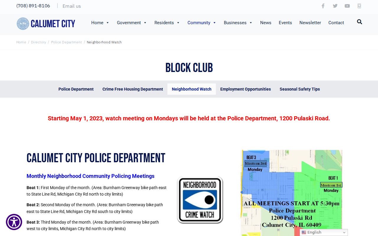
The official page is the strongest local contact route found for block clubs, even though it is not a roster of Calumet City neighbors.
Start a Calumet City Block Club
The city's block-club form collects a proposed club name, street coverage, ZIP, purpose, activities, and contact details. It offers a practical route when no group appears for the block. The inspected form was dated or hosted in 2021, so ask the city or Police Department whether the same form and submission channel remain current.
Neighborhood Watch
Police Department route for beats, watch information, and block-club contact.
Calumet City Historical Society
760 Wentworth Avenue; local photographs, artifacts, and historical context, not a current resident roster.
Public Library
660 Manistee Avenue; local-history referral, catalog, newspapers, phone books, and digital archive route.
Calumet Heritage
A regional directory of heritage organizations, not an association membership list.
No complete official inventory of Calumet City associations, HOAs, civic councils, or member directories was found. Ask for a block-club contact rather than requesting private member names.
Voter Limits for Calumet City Neighbors
The Illinois voter Registration Lookup requires first name, last name, birth date, ZIP Code, and, when prompted, street number and street name. It is designed to let one person verify registration and election information. It is not a downloadable block directory.
Illinois law restricts and redacts fields in public voter material under 10 ILCS 5/1A-25. The suburban Cook County voter-information page supplies the local elections handoff, but no unattended block result was inspected. A ward or precinct can describe civic geography without establishing the identity of every nearby resident.
Address Confidentiality Program participants may use a substitute address under Illinois law. Driver data, utilities, deliveries, and other sensitive household information are not part of a lawful neighbor lookup. A missing public result may reflect a limit or protected route, not absence from the community.
Official and Commercial Neighbor Results
Official rolls are narrower but disclose their custodian and purpose. Commercial neighbor tools may merge old addresses, phone data, namesakes, and scraped material without explaining the date or source. Do not treat a compiled profile as a current household fact.
| Measure | Official Record | Commercial Compilation |
|---|---|---|
| Source | Named county, city, or state custodian | Often blended from several feeds |
| Best use | Parcel, deed, ward, or individual registration fact | Possible lead requiring confirmation |
| Date context | Record or index date is often visible | May be unclear or stale |
| Proof of occupancy | Usually limited | Not reliable without an official match |
For an entire named road, use the Calumet City street directory workflow. For the immediate block, keep the work tight: one source parcel, touching parcels, a short radius, and a community contact.
Privacy for Calumet City Neighbors
Public records do not justify watching someone, publishing sensitive details, or confronting a household. The safest record is often a limited fact: this parcel has this PIN, this deed was recorded on this date, or this address lies in this beat. Names still require identity checks, and a map pin may be close rather than exact.
Use public information to understand the block, reconnect in a respectful way, research local history, or route a civic concern. Contact a person through a normal, consent-based channel. For a danger or suspected crime, use the proper public-safety route instead of conducting surveillance.
Lawful use. Calumet City neighbor records are for civic curiosity and personal safety awareness. Never use them to stalk, intimidate, harass, or harm anyone.
Note: A public portal match is a lead, not proof of identity, present occupancy, household relationships, or personal conduct.